


Discussion
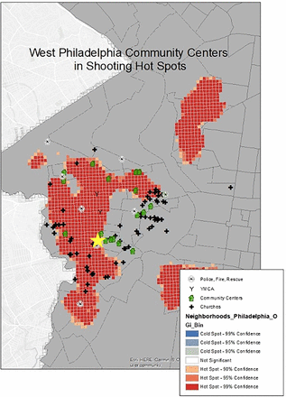
To our knowledge this is the first study to prospectively select STB training locations by using GIS software to identify potential training sites within areas of high incidence of penetrating injury. We found that this method effectively identified locations within areas of violence “hot spots” in our community though problems with receptivity to hosting a training persisted. We ultimately identified a location within a hot spot that was willing to host a training where we found a committed target audience who demonstrated significantly improved skills and knowledge after the course. Interestingly, in the year after the training, no participants in our small cohort were present during a situation involving a life-threatening bleed where they could have used their newfound skills, however, participants continued to exhibit a positive attitude toward bleeding control intervention should such a situation arise. Together this study supports that GIS software is a useful adjunct to identify communities most likely to benefit from STB training, including those with individuals who are receptive to participating.
The STB Campaign has demonstrated that bleeding control interventions such as the application of pressure and tourniquets are potentially life-saving skills that can be effectively taught to laypersons through standardized hands-on training; however, disseminating that training to the communities that need it most continues to pose a challenge.10 Commonly, these trainings are conducted at medical or academic centers where the trainees are often already healthcare professionals and of varying likelihood of encountering a bleeding event outside of the hospital.12 Efforts have been made to impart STB training to predictably high-risk populations, for example individuals whose hands-on job descriptions put them at high risk for workplace injury, but similar efforts are needed to target the neighborhoods that experience a disproportionate amount of the penetrating trauma.22 Targeting inner-city high school students has shown promise, but the participants may not be the most at-risk individuals.14 Given the recidivism of violent events, surveys of hospitalized trauma victims suggest that violence survivors are receptive to these trainings and intervening, however, the strategy of how best to identify effective training locations to reach these people and execute the trainings themselves remains elusive.13
This study demonstrates that GIS software is an effective means of identifying training locations within violent injury “hot spots”. Strengths of our study include using city-wide data rather than institutional data as the source of violent events as well as including a wide variety of community centers as potential training locations, at least two of which were receptive to hosting a training. We achieved a high proportion of follow-up responses at 1-month (100%) and 12-months (80%) and were encouraged that our approach selected a population capable of employing bleeding control skills given the positive and persistent effects of the training on participant knowledge, skills and willingness to help.
Interestingly though, none of the study participants applied their training or used a tourniquet in the year after the course despite the large volume of penetrating trauma victims transported to our Level I trauma center from the vicinity of the training location—in fact the volume increased during the study period.23 Although it is possible that our training failed to recruit our target demographic, an alternative and likely explanation is that the COVID-19 pandemic took hold of our country in the months immediately after the training as did social distancing mandates. Thus whereas the violent crime rate increased, so did social interaction, likely limiting participant availability to help in life-threatening situations during follow-up.
Although we hypothesize the lack of utilization of skills by our trainees has more to do with a competing public health crisis than a failure to select a community in need, it does allude to the persistent challenge of identifying not just individuals and locations at risk, but individuals and locations willing to help. For example, of the eight locations we contacted, only two were open to hosting a training. Further, despite engagement and outreach to community members of all ages, our study participants were largely comprised of engaged but older individuals who may have been less likely to find themselves at the scene of a shooting. Additionally, we did not anticipate the installation of the bleeding control station in a locked basement, severely hampering its ready access and potential for impact in the event of a nearby shooting.
Traditional means of promoting community engagement include town halls and targeting community leaders for buy-in, but a novel potential approach to addressing this limitation might lie again in GIS software.24 For example, traditionally if our goal was to target young people, we could focus on locations that offer sporting activities such as recreation centers, however a more objective means might be to gather information on the mean age of a given neighborhood or even community center complement thus creating another layer for our hot spot map to identify training locations based on participant age. Other potential considerations besides age to consider include ways to use the degree of involvement by community leaders, violence intervention teams, or trainings from other organizations such as the American Red Cross as surrogates for potential interest in being a potential training location. Future work should analyze if participants identified through these microtargeted approaches are more likely to not only witness a life-threatening trauma event but to perform a life-saving intervention.
A notable facet of our study is that of the willing 15 trainees, 20% were healthcare professionals and two had taken the course before. This potential selection bias may have overestimated the observed increase in participants’ bleeding control knowledge and skills postcourse as they started from a higher baseline familiarity. Nevertheless, all participants, regardless of their prior STB or healthcare exposure, demonstrated post-course improvement in their bleeding control skills, knowledge, and attitudes. Thus, we think the STB course achieved our goal of increasing overall bleeding control skills and knowledge in a community impacted by gun violence even in the setting of prior healthcare exposure.
Further, our recruitment efforts were hampered by unforeseen circumstances. After the completion of this study, the COVID-19 pandemic and social distancing mandates prevented our team from hosting additional STB courses in the immediate years that followed this project. This limited our efforts to recruit more sites and participants not only due to public health concerns, but also personnel and budgeting constraints that impacted many of the community service-minded institutions in our area. However, we are happy to report that we have recently reinvigorated this project using GIS mapping to select STB training locations in partnership with community organizations. Even with new study team members, we have found GIS mapping to be a sustainable method to target our STB training efforts in violence hot spots and that community centers are increasingly receptive to hosting an event.
A final limitation of our approach is cost. Like many STB training programs, our trainers are volunteers, yet funding constraints still end up limiting the number of participants and locations due to the ability to provide participants with supplies thus making this a single-center study. In addition, the cost of GIS software is another potential specific limitation for mass implementation of our targeted approach to choosing STB locations. For example, the software we used, ArcGIS, ranges in cost from US$700–4,200 a year, posing a potential financial barrier to employing this software to identify violent hot spots. Draper et al foresaw this as a potential limitation to the equitable use of GIS technology to identify efficient training locations.12 They used geospatial software to retrospectively analyze whether existing STB training locations were in violent hot spots, however, the real triumph of their study is that they did so using Rosymap, a homegrown statistical coding package for the free, open-source programming language and software environment R V.4.3.2. They have subsequently offered the raw code freely to the public, providing an open-source GIS software solution for institutions interested in using a targeted approach to select training locations on a limited budget and hopefully promoting the utility of this potentially paradigm-changing approach to choosing STB training locations.
